The Science Behind Hurricanes
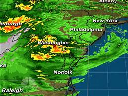 Twenty-seven people have died and President Obama has declared New York a major disaster zone as the Superstorm Sandy continues to move across and devastate the Northeast.
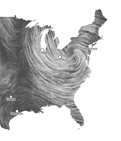
Sandy is one of the largest hurricanes to ever strike the United States. The storm covers an area of more an 1,000 miles. The storm has gone from a Tropical Storm to a Hurricane, back to a Tropical Storm and is now considered a Nor’easter.
Here’s a quick roundup of the damage and destruction Sandy has caused (from MSNBC):
- About 8.1 million homes and businesses were without power across 17 states, and nearly half of the outages were in New York and New Jersey.
- A massive fire destroyed at least 50 homes in Breezy Point, a seaside community in Queens, N.Y.
- Seven subway tunnels under the East River in New York City were flooded, leading MTA Chairman Joseph Lhota to declare: “The New York City subway system is 108 years old, but it has never faced a disaster as devastating as what we experienced last night.” Subway service was unlikely to resume for 4 to 5 days, Mayor Michael Bloomberg said.
- Half of Hoboken, N.J., was underwater, preventing emergency crews from reaching areas of the city, according to Mayor Dawn Zimmer.
- At least four towns in north New Jersey — Moonachie, Little Ferry, South Hackensack and Hackensack — were submerged by up to 6 feet of water after a levee broke.
- More than 15,000 flights have been canceled so far and New York City’s airports remained closed Tuesday. Rail traffic was also heavily affected, with Amtrak canceling all of its Northeast Corridor service, in addition to some other lines.
- Rising waters sparked an alert at the Oyster Creek nuclear power plant in New Jersey Monday night, the Nuclear Regulatory Commission said.
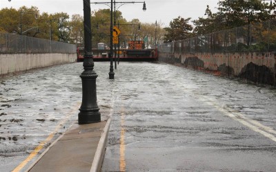
- Seawater surged into lower Manhattan and areas of Brooklyn, submerging entire streets and parks Monday. An all-time record tide level of 13.88 feet was set at The Battery in Lower Manhattan, Monday night, breaking the previous record of 11.2 feet from 1821, as well as Sandy Hook, N.J., shattering the previous record from the Dec. 1992 Nor’easter and Hurricane Donna in 1960, according to weather.com.
The following information is excerpted from The Tornado Tube Book.
Hurricanes and typhoons are not just violent winds. They are giant, whirling storms that develop in a special way. Hurricanes form only in the tropics where extremely moist air and heat are concentrated over the ocean, near the equator. The water temperature must be at least 80o Fahrenheit both day and night. A wet season with increased rainfall begins in late spring and lasts to early autumn. This is the time of year when hurricanes develop. Evaporation of the warm water into the atmosphere over the ocean makes the air very moist. Winds blowing across the ocean in different directions begin to push masses of warm, moist air toward each other. This event is called convergence. When the air masses collide, the air in the center starts to rise, forming an updraft. At high altitudes, the moist air of the updraft begins to cool and water droplets form. These water droplets form clouds. Large cumulonimbus clouds begin to grow and thunderstorms develop. More thunderstorms form as more convergence and updrafts occur. If the thunderstorms do not dissipate, they may start to gather together. This formation is called a tropical disturbance. Many more thunderstorms join the disturbance. This weather event becomes large enough to be influenced by forces created from the Earth’s rotation.
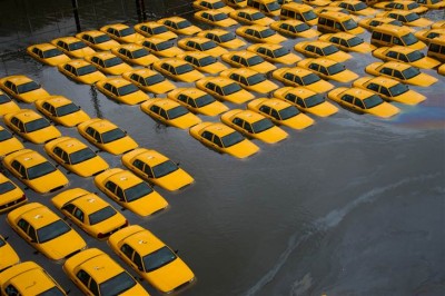
A parking lot full of yellow cabs is flooded as a result of Hurricane Sandy on Tuesday in Hoboken, NJ (Charles Sykes / AP)
The tropical disturbance begins to swirl and becomes a vortex of thunderstorms. Updrafts are continuously pulling more air into the disturbance. When the winds begin to blow continuously at 23 miles per hour, the storm becomes a tropical depression. The tropical depression continues to gain power and becomes a tropical storm when the wind speed becomes 40 miles per hour. At any time, the disturbance, depression, or storm can run out of hot, moist air and weaken or die out. If it continues to gain strength and reaches 74 miles per hour we call it a hurricane.
Hurricanes have top wind speeds of at least 74 miles per hour, but wind speed can reach 180 miles per hour. The closer you are to the storm’s center, the faster the wind will be. The top wind speed will be reached within 60 miles from the center of the hurricane. As you move away from the center, wind speed is slower. At 300 miles from the center, the wind speed may be only 18 miles per hour. The energy of a hurricane comes from the heat released when water vapor condenses to liquid water. The atmosphere above a tropical ocean is the only place enough warm, moist air is available to produce the energy necessary to create a hurricane.
The movement of a hurricane is somewhat predictable. It is so large that it moves with the Earth’s wind currents that surround it. These wind currents are very large and steady and don’t change course abruptly. Therefore, hurricanes usually travel in one of these wind currents until they meet another wind current, then they may change direction. If a hurricane changes course, it could pass over the same area twice. Sometimes one of these storms stalls over an area for days.
A hurricane covers a very large area. Sometimes a tropical storm can have a cloud system that is 2,000 miles in diameter. Typically, a hurricane is about 300 miles across. That is about the distance from Chicago, Illinois to Columbus, Ohio. An average hurricane is about 800 to 5,000 times as wide as an average tornado. Hurricanes usually travel across the sea and land at 10 to 32 miles per hour. Some may travel at speeds up to 50 miles per hour. The path of a hurricane usually covers thousands of miles, most of it over the ocean.
It is very important to track these huge storms and to make accurate predications about their movements. Many people live in areas affected by hurricanes. If the National Hurricane Center scientists believe a hurricane is threatening to reach a populated area within 24 hours, they will issue a hurricane warning. People prepare by gathering and sheltering property and boarding up homes and businesses. Sometimes people will even be evacuated from an area if the forecast calls for an extremely strong storm. Many lives have been saved by these preparations.
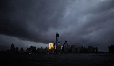
A general view from Exchange Place shows the skyline of lower Manhattan in darkness after a preventive power outage caused by giant storm Sandy in New York on Tuesday. Millions of people in the eastern United States awoke on Tuesday to flooded homes, fallen trees and widespread power outages caused by Sandy, which swamped New York City’s subway system and submerged streets in Manhattan’s financial district. (Eduardo Munoz / Reuters)
To study conditions inside hurricanes, teams of pilots and weather scientists fly regular missions into these storms. They get measurements of wind speed, temperature, air pressure, and other weather conditions at different altitudes. These investigations help scientists make predictions about hurricane formation and movement. The National Weather Service names hurricanes to quickly identify them. The names are assigned in alphabetical order alternating between female and male names. There are separate lists of names for hurricanes in the Atlantic and Pacific oceans.
You can create your own Hurricane in a Bottle and watch how a vortex is formed. Visit the experiment page for the complete activity.



What a great tutorial on hurricanes. Thanks for putting all this information together — I’ll be sharing it!
Crazy scary!!!